
Videos
Plate tectonics works today in the same way as in the past. Can you project the future positions of the continents by looking at a map of their present positions and the positions of the mid-ocean ridges (see Fig. 2.5)? Which oceans are growing and which are shrinking? Where will new oceans form?
FIGURE 2.5 The major features of the sea floor. Compare this map with Figure 2.6.
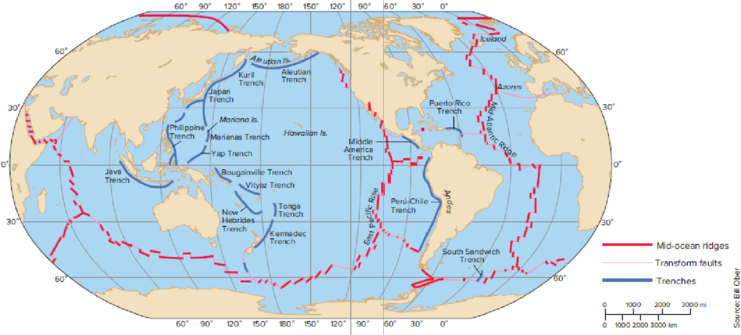
To predict: The future positions of the continents by looking at the map of their present positions and the positions of the mid-ocean ridges.
Introduction: The continents in the earth’s crust or plates that float on the mantle portion of the Earth are called plate tectonics. The movement of plate causes formation of the mountain and continents over a millions of years that result in the geographical changes of the Earth.
Explanation of Solution
Plate tectonics are the lithospheric plates composed of continental and oceanic lithosphere. Refer to Fig. 2.5, “The major features of the sea floor”, in the text book. The future positions of the continents are given in Table 1.
Tabular representation: The following table shows the future positions of the continents.
Table 1: The future positions of the continents
| Continents | Future positions |
| North and South America | Farther west toward the Pacific Ocean |
| Europe and Asia | Farther southeast |
| Australia | Farther northeast |
| Africa | Farther east |
To determine: The oceans that are growing and shrinking.
Introduction: The continents in the earth’s crust or plates that float on the mantle portion of the Earth are called plate tectonics. The movement of plate causes formation of the mountain and continents over a millions of years, which result in the geographical changes of the Earth.
Explanation of Solution
Plate tectonics are the lithospheric plates composed of continental and oceanic lithosphere. Refer to Fig. 2.5, “The major features of the sea floor”, in the text book. The shrinking ocean is Pacific Ocean (expected to be narrower) and the growing ocean is Atlantic Ocean (expected to be wider).
To determine: Where will the new oceans form.
Introduction: The continents in the earth’s crust or plates that float on the mantle portion of the Earth are called Plate tectonics. The movement of plate causes formation of the mountain and continents over a millions of years, which result in the geographical changes of the Earth.
Explanation of Solution
Refer to Fig. 2.5, “The major features of the sea floor”, in the text book. The edges of several plates are formed by the mid-ocean ridges. At this point, the lithospheric plates move apart to form the new oceanic lithosphere (new sea floor). If the plate contains a block of continental crust, the plate moves away from the ridge, and the continent is carried along with the plate.
Want to see more full solutions like this?


- Choose the answer that best fits the blank. Hundreds of years ago, geographers first noticed that many of Earth's continents have shapes that seem to "fit together" like a big puzzle that was broken up. Because of this, they theorized that the continents had slowly changed position over time. The explanation for exactly how this movement occurred, however, did not become clear until geologic research in the 1960s led geologists to formalize the theory of _______ . This scientific theory states that continents move because they are a part of a series of plates that form Earth's crust. These plates shift around the planet, moving on a bed of liquid, hot rock known as magma. A.plate tectonicsB. continent driftC. paleomagnetismarrow_forward2) The Ring of Fire is located around the Ocean. 3) Why do so many volcanoes and earthquakes occur around the Ring of Fire? 4) What scale is used to measure the magnitude of an Earthquake? 5) Earthquakes that occur under the ocean can cause giant waves called 6) The Hawaiian Islands and other chains of islands located in the center of a tectonic plate are unique because they form over aarrow_forwardPlate tectonics can contribute to a. volcanoes and earthquakes. b. formation of supercontinents. c. increased weathering and CO2 sequestration.arrow_forward
- The earth is about 4.6 billion years old. Based on the formation of seafloor spreading, why do you think that the oldest ocean floor is only about 200 million years old?arrow_forwardThe flow of magma directly applies force to which of these crustal features? mountain ranges mountain ranges tectonic plates tectonic plates oceans oceans glaciersarrow_forwardClimate is the result of a variety of global processes. What of the following is a climatological driver? rotation of Earth hydrosphere properties oceanic currents concertation of sun irradiances all of the abovearrow_forward
- DQuestion 1 Cuvier was known for introducing the world view of Catastrophism. Explain this world view. Ois the idea that land forms were created by the same processes that occur today-mountain building processes, erosion, and deposition. These slow processes occur continually, and over long periods of time, their effects build mountain ranges and carve out canyons. No catastrophes are needed to explain the Earth's landforms - no special violent actions, just the constant action of the normal, slow processes of erosion and untain-building. O This is the idea that the world was shaped by tremendous, violent catastrophic events unlike anything humans have ever experienced. Landforms - such as mountains and canyons - were formed by catastrophes - and the biological world also reflects the influence of catastrophic events. Whole communities of ancient animals went extinct because of violent catastrophes, and then they were replaced by entirely new communities.arrow_forwardTrends Along Latitude Lines Use the globe icon to change the view to a flat map, and use the gear icon to turn “on” the gridlines. Scan across the globe along each of the latitude lines listed below, and record the biome types present. Latitude Biomes noted at this latitude 60°N 45°N 30°N 15°N 0° In 3-4 sentences, please summarize what you discovered regarding patterns of biome distribution in relation to latitude. Try to include points gathered from lecture material (or earlier in this lab exercise) to deepen your understanding.arrow_forwardhttps://docs.g.. O Titanica 1 p What metaphor did Wegener use to explain HOW the continents moved? an icebreaker ship cutting through sea ice a hot knife cutting through butter a child falling off a tricycle a bird cutting through a cloud Who published the idea of seafloor spreading in 1962? 1 point Harry Hess Harry Houdiniarrow_forward
- The _______________ is open ocean from the shoreline to a depth of 200 m. (a) benthic environment (b) intertidal zone (c) neritic province (d) oceanic province (e) aphotic regionarrow_forwardExplain how plate tectonics cause earth tremorsarrow_forwardWhich of these geologic features are sites where magma ruptures from tectonic plates? Trenches Hotspots Oceanic ridges Faultsarrow_forward
 Biology (MindTap Course List)BiologyISBN:9781337392938Author:Eldra Solomon, Charles Martin, Diana W. Martin, Linda R. BergPublisher:Cengage Learning
 Biology Today and Tomorrow without Physiology (Mi...BiologyISBN:9781305117396Author:Cecie Starr, Christine Evers, Lisa StarrPublisher:Cengage Learning